Forces of nature create iconic landforms along the Hexi Corridor

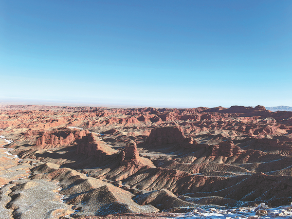
In the Hexi Corridor, an ancient trade route in Northwest China, its historic magnitude is rivaled only by its majestic nature, which continually inspires the heroic stamina required to endure this rugged land.
Yet, natural forces that shaped this landscape were at work tens of millions of years before Homo sapiens ever walked the Earth, a fact that travelers to the corridor in Gansu province are constantly reminded of.
The corridor owes its very existence to the collision between the Indian and the Eurasian plates which began around 50 million years ago and continues slowly even today. Direct results of the collision include the formation of plateaus, the lifting of mountain ranges and the development of various landforms.
The Qilian Mountains, formed by the tectonic collision, became nature's solution to the region's widespread drought. Without the constant supply of meltwater, which fed major rivers and replenished underground aquifers, life would have been unsustainable.
To witness the region's remarkable landforms, one must visit Zhangye and Dunhuang, which played pivotal roles in the history of the Hexi Corridor as oasis towns.
In Zhangye, this means exploring the Danxia landscape — a term coined by Chinese geologists in the 1920s.
Over 50 million years ago, this terrain lay beneath the ocean until tectonic forces thrust it upward, exposing its layered sedimentary rocks.
Danxia means "the red afterglow" in Chinese, indicating the landscape's dominant rusty red hue produced by iron oxide. Zhangye boasts several Danxia sites, including the Pingshan Lake Grand Canyon and Zhangye National Geopark. The latter is home to what's known as the "Colorful Danxia", where red serves as the backdrop to a striking palette shaped by minerals — iron sulfide responsible for yellow hues while high concentrations of chloride and iron silicate for shades of green and blue.
Different seasons and times of day present various visuals. At sunrise and sunset, the hills burn with a fiery glow. In late winter, a delicate veil of snow softens the gradient layers, making the land look like a delicately frosted cake.
For a breathtaking perspective, visitors can take a helicopter or hotair balloon ride over the geopark. From above, the undulating terrain resembles the rippling ocean floor it once was.
To view a more petrified sea, head to the Dunhuang Yardang National Geopark.
Yardang (Yadan in Chinese) refers to land formations sculpted by relentless desert winds. Whistling past the jutting, silent turret of stratified sandstone, the wind — a perennial force to reckon with in this part of the world — has bestowed a haunting, yet mesmerizing name: Devil City.
The land formations take on three distinct shapes — walls, towers and pillars. Together, they rise like nature's own Great Wall, standing sentinel over the vast Gobi Desert.
Within the geopark, a 5-square-kilometer area is dominated by neatly aligned land formations — so precise in their arrangement that they resemble a fleet. Yet, the moment they were about to sail into the vast ocean they once belonged to, they froze as if under a spell — waiting to captivate every visitor who beholds them.
Tong Yunshan contributed to this story.
Contact the writers at zhaoxu@chinadaily.com.cn


